Rights
of Way
Principally to do with Vehicular
Rights of Way, but does contain some information about other classes of
user as well.
What
is a 'Right of Way'?
Who can use
it?
Green Lanes
Where
can I find information about local Rights of Way?
Other
Rights of Way web sites I know about
Back home
What
is a 'Right of Way'?
A right to pass, and repass over a particular route on
the land.
One can thus pass along the right of way, how you do so
depends on the nature of the given right, on some you can only ride a bike,
but on others you can use any means of passage you feel like, be it your
feet, a bike, a horse, or a motor vehicle.
Crudely speaking there are four main classes:
Footpath - only usable
by the public on foot, no bikes, horses or motorized things allowed.
Bridleway - usable
on foot, bike or horse back.
Road, Used as Public Path
- a bit of an anathema these, as they carry 'at least' footpath rights,
probably bridleway, and most vehicular. This was a mess invented
by Parliament, and the subject of much debate ever since!
Byeway Open to All Traffic
- the highest status of Right of Way. Open to ALL traffic, and the
subject of much misunderstanding among certain groups....
Then there are 'ucr', or 'uccr', these are unclassified
roads, which may, or may not be Rights of Way, and if Rights of Way, may,
or may not, have vehicular rights.
Back to top
Who can
use it?
Any member of the public may use
a Right of Way.
There are limitations to be aware
of, notably that a Right may be suspended for either a defined, or un-defined
period, for example during open cast coal working.
Generally one can use a Right of
Way, if one making a valid journey, which may be to go and see your Aunt
Maud's grave, or to admire the scenery along the way.
Remember, do not cause damage to
the Way, or the flora and fauna that is legally along it. One may
remove something that prevents your passage. This is called 'abating'.
Do so with care, because if what you consider to be an obstruction is actually
a limitation then you are in trouble...
Any class of user up to that permitted
by the class permitted by the Way's classification may use a Right of Way,
but if you are a bike rider on a Bridleway, then you have to give way to
all other legitimate users.
Back to
top
Green
Lanes
This is the generic name for Vehicular
Rights of Way.
These are the ancient roads of our
land. Some have been lost in antiquity, and other some would see
lost.
They are out grandchildren's heritage,
we must do our utmost to ensure that these roads are open to use by all
the public, as they once were.
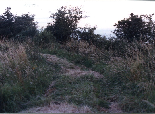 This
was once a busy route between local farms, a village or two, and a mill.
Today it is a quite Bridleway, ahead, and Byeway, behind. At this
point a 'UCR' joins, and leads out onto the tarred road. Due to a
quirk in the law, the bridleway actually carries vehicular rights, just
to add to the confusion. Follow this link
for a description of this lane complex.
This
was once a busy route between local farms, a village or two, and a mill.
Today it is a quite Bridleway, ahead, and Byeway, behind. At this
point a 'UCR' joins, and leads out onto the tarred road. Due to a
quirk in the law, the bridleway actually carries vehicular rights, just
to add to the confusion. Follow this link
for a description of this lane complex.
Back to top
Where can I find information about
local Rights of Way?
A good starting point is the Ordinance
Survey 'Land Ranger'(c) series of maps.
These show with varying degrees
of accuracy the majority of Rights of Way in an area. You must be
aware that due to the lead time it takes to get the data from many councils
tot eh Ordinance Survey, and then onto the actual map there may be errors,
sorry, there are errors in these maps.
Once you've had a look at the Land
Ranger map for the area you are interested in, take a trip to the local
council office and ask to speak to the 'Rights of Way Officer', or, if
that gets a blank stare try the 'Footpaths Officer'. Explain that
you want to see the 'Definitive Map, and Statement' (or the 'Footpaths
Map'). This is real starting point for the current status of a Right
of Way.
With any luck this person will
be a pleasant soul, over worked, under paid and glad to be of assistance,
but others are less desirable.... If you are working one your home
turff, then it is well worth cultivating a good working relationship with
this person, they can save you a lot of time in the long run. Listen
carefully to what they say, one I know well said in passing "Did you know
that this didn't remove vehicular rights from this bridleway, and do you
take sugar in your coffee?" I didn't and I do...
If, like me, research is your thing,
then get into the local records office. This is a real treasury.
In my experience the staff are helpful, its a pleasant change for someone
to ask to see the maps for Bloggston over the last 300 years as opposed
to the never ending search for lost relatives. I well remember having
three archivists looking at one very nicely drawn 18th centruy map which
they'd never seen before. I could write pages about what to look
for on these old maps, but put simply we are looking to see if the rod
was owned by someone other than the Parish, and if there were any limitations
to its use.
Finally the Highways Department.
Most of their time is spent dealing with the tarred road network.
Here you are looking to see the 'List of Streets' - roads that are maintainable
at public expense. The list may in many forms, ranging from a simple
list, to a very nice set of maps and supporting documents. Here again
take time to cultivate contacts. One contact I have was very 'anti'
vehicular use of green lanes, but with a lot of hard work, being polite,
but forceful he has become 'neutral'; or may be even slightly pro.
Back to
top
Other
Rights of Way web sites I know about
Mike Cattel (Cheshire)
Mark
Smith (also in Staffordshire)
Dave Tilbury (Hampshire)
Andy Bush (AWDC)
Back to
the top
Back Home